


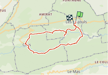
tour du mont de gars

Christine Cadas
User

Length
18 km

Max alt
830 m

Uphill gradient
511 m
Km-Effort
25 km

Min alt
590 m

Downhill gradient
579 m
Boucle
No
Creation date :
2025-01-16 07:43:51.158
Updated on :
2025-01-16 14:46:05.782
6h43
Difficulty : Very difficult

FREE GPS app for hiking
 SityTrail
IGN / Geographical institutes
SityTrail Plus
The world is yours!
About
Trail Walking of 18 km to be discovered at Provence-Alpes-Côte d'Azur, Maritime Alps, Les Mujouls. This trail is proposed by Christine Cadas.
Positioning
Country:
France
Region :
Provence-Alpes-Côte d'Azur
Department/Province :
Maritime Alps
Municipality :
Les Mujouls
Location:
Unknown
Start:(Dec)
Start:(UTM)
328168 ; 4861271 (32T) N.
Comments